



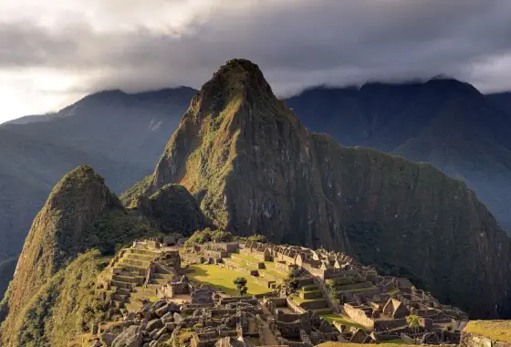
The Incas emerged as a small kingdom in the Cusco valley in the 13th century. Pachacuti, who came to the throne around 1438, defeated neighbouring peoples and began a great expansion. Under his son and grandson the empire stretched from today’s Ecuador to central Chile. The Incas called their state Tawantinsuyu, “the Four Regions”.
Government and roads
The empire was linked by the Qhapaq Ñan, a road network running along the Andes with a total length of tens of thousands of kilometres, now on the UNESCO World Heritage List. Rest stations and relay runners allowed rapid communication. Without writing, the Incas kept population and tax records with coloured knotted cords called quipu.
Agriculture and architecture
Hillside terraces, irrigation canals and storehouses fed a large population in a harsh landscape. Stone walls fitted perfectly together without mortar are the hallmark of Inca architecture. Machu Picchu, on a mountain ridge, is a 15th-century royal estate and a UNESCO World Heritage site.
The Spanish conquest
In the late 1520s epidemics from Europe and a war of succession between the brothers Huáscar and Atahualpa weakened the empire. In November 1532 a small Spanish force under Francisco Pizarro captured Atahualpa at Cajamarca. Despite paying a huge ransom, Atahualpa was executed in 1533 and the Spanish entered Cusco. Inca resistance continued at Vilcabamba until 1572.
The Sapa Inca and Government: A State of Four Regions
At the head of the Inca state stood the ruler known as the Sapa Inca, who was believed to descend from the Sun God Inti. The empire was divided into four regions extending in four directions from Cusco: Chinchaysuyu, Antisuyu, Qullasuyu and Kuntisuyu. Each region was governed by governors, beneath whom lay a hierarchy based on groups of a thousand, a hundred and ten.
The state often left the local leaders of conquered communities in office, asking in return for loyalty and labour. Some communities were resettled in distant regions to secure loyalty or to work new farmland (the mitmaq practice). Quechua was promoted as the official language; today millions of people in Peru, Bolivia and Ecuador speak Quechua.
Mit’a, Storehouses and Record-Keeping: A Moneyless Economy
The Inca economy had no money or market system in the modern sense. The state collected labour for roads, terraces and temples through a periodic labour obligation called mit’a. People worked for the state for a set period each year and the state in return provided food, drink and festivities. This system was supported by the storage of goods such as grain and textiles.
State storehouses called qollqa were lined up along roads and at administrative centres. Stored grain was used for the army and the population in times of drought or war. Numerical records were kept with knotted cords called quipu; colour, type of knot and position represented numbers and, according to some researchers, other information as well. The officials who read the quipu were called khipukamayuq. Exactly how this system was read is still under investigation.
The Qhapaq Ñan and the Chasqui Messengers
Qhapaq Ñan is the name of the Inca road system; crossing the Andes, deserts and forests, it forms a network of about thirty thousand kilometres. In 2014 it was added to the UNESCO World Heritage List on a joint nomination by Argentina, Bolivia, Chile, Colombia, Ecuador and Peru. The roads were adapted to difficult terrain with stepped stone paths, bridges, passes and tunnels.
Along the road there were lodging stations called tampu at regular intervals. Runner-messengers called chasqui could cover very long distances in a short time by carrying messages and small loads between stations like a relay race. Suspension bridges woven from grass fibre, such as Q’eswachaka, are still rewoven every year by local communities; this tradition is on UNESCO’s intangible cultural heritage list.
Agriculture at Altitude: Potatoes, Maize and Chuño
Inca agriculture relied on exploiting the climates of different altitude zones. Maize was grown in the valleys, and potatoes and quinoa at higher elevations. Thousands of potato varieties were developed. Potatoes were freeze-dried with the help of frost and sun into a long-keeping food called chuño, and this method was one of the basic elements of storage.
The circular terrace pits at Moray are interpreted as an agricultural experiment site where different climate conditions could be tried in a small area. Terraces served not only to hold soil but also to moderate temperature differences and help irrigation. Llamas and alpacas were used for carrying loads, wool and meat; the wheel was not used for transport. This system made it possible to feed a large population in a high and difficult landscape.
Cusco, Machu Picchu and Religion
The capital Cusco was regarded as the religious and political centre of the Inca world; its name is linked to a Quechua word meaning “navel”. One of the city’s most important buildings, Coricancha, is known as the Temple of the Sun and was described as having walls covered in gold plates. After the Spanish conquest a church was built on the temple’s foundations; today these remains can be seen intertwined. Above the city, Sacsayhuamán is a complex built of massive stone blocks.
Machu Picchu is considered a royal estate built for Pachacuti in the 1450s. It was abandoned after the Spanish conquest and made known to the world by Hiram Bingham’s expedition in 1911. In the religious system Inti (the Sun), Viracocha (the creator god) and Pachamama (Mother Earth) held important places. The mummies of dead rulers were preserved and carried in ceremonies.
From Civil War to Vilcabamba: Resistance After the Conquest
The death of the ruler Huayna Capac in the late 1520s coincided with the spread of diseases from Europe in the region. The succession problem led to a civil war between his sons Huáscar and Atahualpa. As Atahualpa was winning the war, in 1532 Francisco Pizarro’s band of about 170 men reached Cajamarca. On 16 November 1532 the Spaniards ambushed and captured Atahualpa. Although he had been promised freedom in return for filling a room with gold and silver, Atahualpa was executed in 1533.
Inca resistance did not end with the conquest. Manco Inca besieged Cusco in 1536; when this failed he withdrew to Vilcabamba and maintained an Inca state there. This state ended in 1572 with the capture and execution of the last ruler, Túpac Amaru. About two centuries later, in 1780, a great rebellion broke out under José Gabriel Condorcanqui, also known as Túpac Amaru II.
Sources and further reading
- Encyclopaedia Britannica, “Inca”.
- UNESCO World Heritage, “Qhapaq Ñan, Andean Road System” and “Historic Sanctuary of Machu Picchu”.
- Garcilaso de la Vega, Royal Commentaries of the Incas.
- Encyclopaedia Britannica, entry “Inca”.
- UNESCO World Heritage Centre, “Qhapaq Ñan, Andean Road System” (2014) and “Historic Sanctuary of Machu Picchu”.
- Terence N. D’Altroy, The Incas (Wiley-Blackwell).
People also ask
What was the Inca Empire? The Inca Empire expanded from its centre at Cusco in Peru in the 15th century to become the largest Indigenous state in South America.
What was the Inca Empire’s capital? Capital: Cusco (Peru).
When did the Inca Empire end? End: 1532 – 1533, Spanish conquest.
Leave a comment
Your email address will not be published. Required fields are marked *