



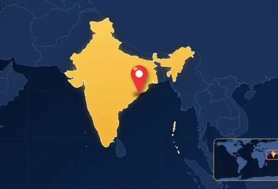
The eastern Indian state of Odisha is bracing for Severe Cyclonic Storm Akvan, which formed over the Bay of Bengal. According to forecasts issued by the India Meteorological Department (IMD) on 19 November 2026, the storm is expected to make landfall around midday on Friday, 20 November, crossing the coasts of north Andhra Pradesh and south Odisha between Narsapur and Puri, near Gopalpur in Ganjam district. Wind speeds at landfall are forecast to reach 90–100 kilometres per hour, gusting to 110 kilometres per hour.
According to official figures reported by Down To Earth, 105,304 people had been moved to 1,224 cyclone and flood shelters as of 19 November, and evacuations were continuing. The first figures reported by Gulf News during the day were above 72,000; the number rose rapidly over the course of the day. Odisha Chief Secretary Anu Garg said the state was fully prepared for the storm, and the central government pledged support to the state.
Where is the storm and how strong is it?
According to Gulf News, citing IMD data, at 5:30 a.m. local time on Thursday, 19 November, Akvan was about 530 kilometres south of Gopalpur and about 590 kilometres south of Puri, moving north at about 12 kilometres per hour. Down To Earth reported that the storm had changed course and was heading quickly towards the Odisha coast. The IMD’s Bhubaneswar centre said the storm was “very likely to cross the coast between Narsapur and Puri, close to Gopalpur.”
In the IMD classification, a “cyclonic storm” refers to sustained winds of roughly 62–88 kilometres per hour, while a “severe cyclonic storm” refers to winds of 89–117 kilometres per hour. Akvan’s forecast values fall into this second category. Besides wind, heavy rain also poses a serious risk: the IMD issued extremely heavy rainfall warnings for Kendrapara, Kandhamal, Jagatsinghpur, Gajapati, Ganjam and Puri districts, and an orange alert for other coastal and southern districts, including Mayurbhanj. According to Down To Earth, orange and red warnings are in force for nine districts.
How are evacuation and shelter efforts going?
According to official figures, the largest evacuation took place in Ganjam district, which the storm is expected to hit directly: 45,364 people were moved to shelters there. Gajapati followed with about 18,000 people. Hilly areas at risk of landslides were given priority; about 16,000 people in Gajapati and about 3,400 in Kandhamal were reportedly moved out of such areas. About 9,000 pregnant women close to their due dates were moved to nearby health centres and hospitals.
Across the state, 9,299 shelters were identified and supplied with food, drinking water, medicines and hygiene supplies. Community health workers and childcare centre staff are helping to run the shelters. Officials urged people on the coast and along rivers to stay indoors and keep away from riverbeds and reservoirs. Water levels are being lowered at some dams as a precaution, and night patrols are being carried out along the Rushikulya river in Ganjam.
What measures have been taken?
In Odisha, 60 Odisha Disaster Rapid Action Force (ODRAF) teams, 14 National Disaster Response Force (NDRF) teams and 221 fire service units have been deployed to vulnerable districts. A further 100 teams were assigned to clear roads blocked by fallen trees. Helicopters, cranes and Indian Coast Guard assets are on standby. District administrations were given satellite phones and mobile communication units in case of communication outages.
According to Gulf News, government, government-aided and private schools, as well as childcare centres, are closed in six districts from 19 to 21 November. Fishing has been suspended and all 19,057 fishing boats have returned to shore. At Gopalpur Port, staff were evacuated and cranes were secured. Tourist activity has been banned around Gopalpur, Puri, Satapada and Chilika Lake, and several train services were cancelled or rescheduled.
Why is Odisha preparing so extensively?
The Bay of Bengal is one of the regions of the world most affected by tropical cyclones, and the Odisha coast is among the places these storms frequently strike. The state thoroughly restructured its disaster management after the 1999 “super cyclone,” in which about 10,000 people died. During Cyclone Phailin in 2013, the advance evacuation of about 1 million people was decisive in keeping the death toll limited, and this approach based on early warning and mass evacuation was cited internationally as a model. For Akvan, too, early evacuation is being carried out with a similar “zero casualties” goal.
Experts point out that deaths in cyclones are caused not only by wind but also by storm surges that push seawater inland, by floods triggered by heavy rain and by landslides. For this reason, evacuations in hilly inland areas are as important as measures on the coast. After making landfall, the storm is expected to weaken as it moves inland, leaving heavy rain in its wake.
What does this mean?
Akvan’s landfall and the scale of its impact are not yet certain; its track, intensity and possible damage will become clearer with observations in the coming hours. The measures taken so far show that the early-warning and mass-evacuation model Odisha has developed over the past two decades is being tested once again. For people living in the region or planning to travel there, following official announcements from the IMD and the state government will be the most reliable course.
This report was compiled as of 19 November 2026, 20:30 Türkiye time; follow developments as they are updated.
Frequently asked questions
Where will Cyclone Akvan make landfall?
According to the IMD, Akvan is expected to make landfall around midday on 20 November between Narsapur and Puri, near Gopalpur in Odisha’s Ganjam district.
How many people have been evacuated?
According to official figures, more than 105,000 people had been moved to 1,224 shelters as of 19 November; the largest evacuation was in Ganjam district, and efforts are continuing.
How strong are the storm’s winds?
The IMD expects sustained winds of 90–100 kilometres per hour at landfall, with gusts of up to 110 kilometres per hour; these values fall into the “severe cyclonic storm” category.
Sources and further reading
- Down To Earth, “Odisha braces for Severe Cyclonic Storm Akvan; evacuates over 0.1 million people”, 19 November 2026.
- Gulf News, “Cyclone Akvan approaches Odisha: 72,000 evacuated, schools shut amid heavy rain alert”, 19 November 2026.
- Deccan Chronicle, “Cyclone Akvan most likely to make landfall close to Odisha’s Gopalpur” (live coverage), 19 November 2026.





Leave a comment
Your email address will not be published. Required fields are marked *